絵で見て考える中川運河の「らしさ」
A3号 [人工の自然堤防]
The “Character” of the Nakagawa
Canal Thought of in Pictures:
issue A3 [Man-made Natural Dykes]
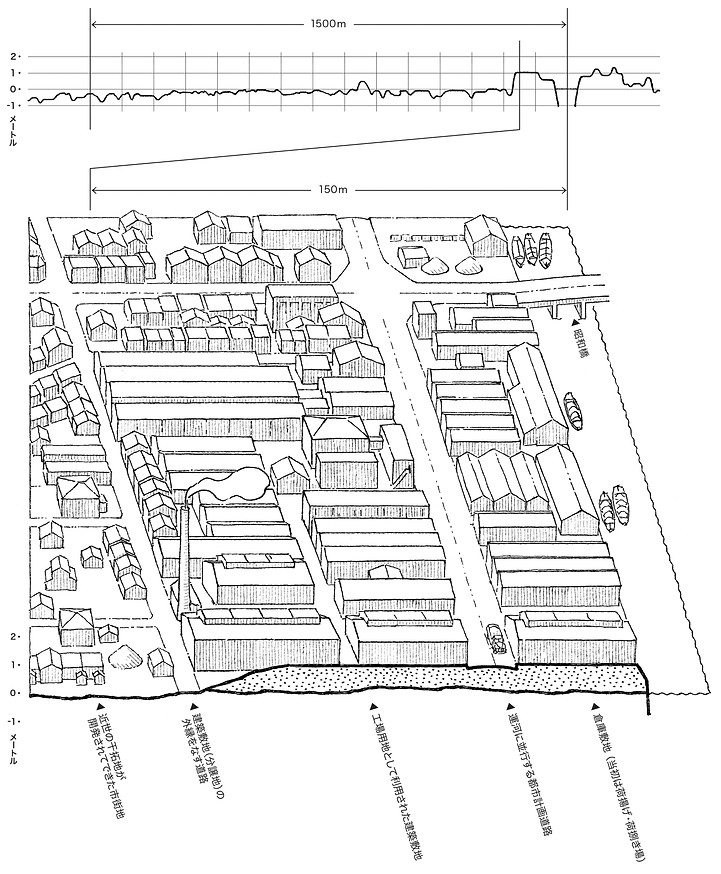
断面図と鳥瞰イラストを援用して、
中川運河の「人工の自然堤防」と河川の「自然堤防」の類似点を可視化
clarification of the similarities between the ʻman-made natural embankmentsʼ of the Nakagawa Canal and the ʻnatural embankmentsʼ along rivers, with the help of cross-sectional maps and bird's-eye view illustrations
表紙:旧中川運河と現在の中川運河の比較
中川運河の建設にあたっては,「運河土地式」の区画整理が適用された。開削土を両岸に盛ることにより,水路を開くと同時に低湿地の土地条件を改良し,帯状の運河エリアにおいて,水・陸両面から空間の利用価値を高めたのである。
front page: comparing the former Nakagawa river with today’s Nakagawa Canal
For the construction of the Nakagawa Canal, the Canal-Land Formula of land readjustment was applied. By filling both banks with excavated soil, the canal was opened up and at the same time the land conditions in the low marshy areas were improved, thus increasing the use value of both water and land areas along the canal strip.

中川運河の「人工の自然堤防」は、現地に立つことで容易に体感できるほど顕著な土地の起伏ではない。
ʻMan-made natural embankmentsʼ at Nakagawa Canal re not as pronounced land undulations that can be easily experienced by visiting the site.
河川の自然堤防として、木曽川から分流ししていた津島市の旧佐屋川と天王川の取り上げ
As a reference for natural levees on rivers, the former Saya River and Tenno River in Tsushima City, which were diverted from the Kiso River, were taken up.


絵で見て考える中川運河の「らしさ」

都市の「らしさ」は、直感的には理解できても、言葉にしにくいものです。視界に収まらないスケールの大きな特徴、目前にあっても気づきにくいリズム、意識化されていない付き合いの作法など。そうした言語化しにくい町の底流にある文脈を可視化するために、『絵で見て考える中川運河の「らしさ」』と題する本シリーズを制作しました。
これまで発行した号は、都市コミュニケーション研究所のウェブサイトに掲載されています。
絵からヒントを得ながら、未来の都市づくりのために想像力を働かせましょう。